 2023, Vol. 41
Institute of Oceanology, Chinese Academy of Sciences
Article Information
- SUO Anning, ZHOU Weiguo, DING Dewen
- Suitability evaluation on marine ranching in Guangdong, South China
- Journal of Oceanology and Limnology, 41(2): 778-791
- http://dx.doi.org/10.1007/s00343-022-1423-8
Article History
- Received Dec. 14, 2021
- accepted in principle Mar. 7, 2022
- accepted for publication Apr. 13, 2022


2 Southern Marine Science and Engineering Guangdong Laboratory (Guangzhou), Guangzhou 511458, China
Marine ranching is a new direction in global marine fishery development. It represents fishing ecosystem that relies on marine primary productivity and is constructed based on modern marine engineering technology and management methods. Their functions include fishery resources enhancement, ecological environment restoration, leisure, and entertainment (Zhang et al., 2003; Yang, 2016). Marine ranching can provide continually the quality, fresh, and aquatic products, and improve the ecological environment of offshore areas; it has thus attracted worldwide attention (Kim et al., 2014; Hwang et al., 2015). In October 2017, the Ministry of Agriculture of the People's Republic of China issued the "National Marine Ranch Demonstration Zone Construction Plan (2017–2025)", in which 178 national marine ranching demonstration areas by the end of 2025 were planned. This plan involves the formation of a new marine ranching pattern in offshore seas of the Yellow Sea and Bohai Sea, East China Sea, and South China Sea. At a local level, marine ranching plans have been implemented in China's coastal regions of Liaoning, Shandong, and Hainan Provinces.
The primary task of marine ranching is the selection of suitable sites. Heaps et al. (1997) first proposed a complete technical procedure of artificial reef site selection. Subsequently, Wright et al. (1998) proposed an artificial reef site selection method based on a geographical information system (GIS) layer overlay. Using GIS, Seyed et al. (2015) introduced a new combine Multi-Criteria DecisionMaking (MCDM) tools to evaluate suitability of coral reef site selection. The suitability evaluation method is an important method for site selection in marine engineering for artificial reefs (Xu et al., 2016) and harbors (Sun, 1983). As is typical for artificial marine ecosystems, site selection for marine ranching should first consider habitat suitability. The habitat suitability index is widely used as a quantitative evaluation index to describe the preferences of species to specific environments (Chen et al., 2011). Stalnaker et al. (1995) applied an in stream flow incremental methodology to the simulation and evaluation of river habitat suitability in the 1980s. The Habitat Suitability Model was proposed to describe the habitat quality of wildlife in the early 1980s by the United States Fish and Wildlife Service (Brotons et al., 2004). In the 21st century, several scholars have paid additional attention to niche models, regression models, mechanistic models, and 3S technology for species habitat suitability evaluation. Ding et al. (2018) used the MAXENT niche model to analyze the distribution and habitat suitability of bison, and the high prediction accuracy of the model demonstrated its appropriateness for determining habitat suitability in different regions of China. Kocev et al. (2010) evaluated the suitability of diatoms in Prespa Lake using a multi-target regression tree model. This model satisfactorily detected the environmental conditions affecting the structure of the diatom community and revealed the impacts of nutrients and heavy metals on the structures of diatom communities. Habitat characteristics can influence the compositions and structures of fish communities and are a major determinant factor in assessing the potential for marine ranching production.
In this study, we applied the niche matching theory to explore the ecological suitability model, created an ecological suitability index for marine ranching site selection, and conducted ecological suitability evaluation research for marine ranching sites in Guangdong Province. Our primary goal was to evaluate the ecological suitability model for marine ranching site selection and draw a marine ranching spatial plan framework for Guangdong Province.
2 MATERIAL AND METHOD 2.1 Study areaThe studied offshore areas in Guangdong Province have a total area of 41.93×10⁴ km2, from the east boundary of Dacheng Bay at the junction of Fujian Province in the east to the Ximi River estuary of Yingluo Port at the junction of the Guangxi Zhuang Autonomous Region in the west and to the central boundary of the Qiongzhou Strait in the south. The total length of the continental coastline is 4 114 km, and the total area of internal waters, territorial seas, and exclusive economic zones are 4.89×10⁴ km2, 1.64×10⁴ km2, and 35.40×10⁴ km2, respectively. Considering the municipal and countylevel sea area management boundaries as the principal factor and the integrity of the marine ecosystem, basic marine functional areas, and other natural geographic boundaries, a total of 40 evaluation units were selected to represent the basic unit of ecological suitability evaluation of marine ranching in Guangdong Province (Fig. 1).

|
| Fig.1 Sites selected for marine ranching in offshore areas in Guangdong Province 1: Houjiang Bay; 2: Nanpeng Sea area; 3: Shantou Bay; 4: offshore Shantou Bay; 5: Haimen Bay; 6: Jinghai Bay; 7: Shenquan Port; 8: Jiazi Port; 9: Jieshi Bay; 10: offshore Jieshi Bay; 11: Honghai Bay; 12: Daya Bay; 13: Dapeng Bay; 14: offshore Daya Bay; 15: offshore Shenzhen; 16: Zhujiang (Pearl) River estuary; 17: inner Wanshan Islands; 18: outer Wanshan Islands; 19: offshore Gaolan Sea area; 20: Huangmao Sea; 21: Guanghai Bay; 22: offshore Chuanshan Sea; 23: Beijin Port; 24: offshore Hailing Islands; 25: Shapa Port; 26: offshore Yangjiang; 27: Dianbai Port; 28: offshore Maoming; 29: Bomao Port; 30: Zhanjiang Port; 31: offshore Zhanjiang Port; 32: Leizhou Bay; 33: Wailuo Sea area; 34: offshore Zhanjiang; 35: Qiongzhou Strait; 36: Dongchang Bay; 37: Haikang Port; 38: Longdou Bay; 39: Jianghong Port; 40: Anpu Port. Map review No. YueS(2019)064. |
Data required for the evaluation of ecological suitability of the marine ranching sites are as follows:
(1) Offshore areas: "Marine Functional Zoning of Guangdong Province 2011–2020" map data.
(2) Administrative divisions: 1꞉50 000 basic geographic information map data for Guangdong Province.
(3) Sea depth contours: 1꞉50 000 basic geographic information map data for Guangdong Province.
(4) Basicmarine functional zoning: "Marine Functional Zoning of Guangdong Province 2011– 2020" map data.
(5) Submarine topography and landforms: "Landforms and Environment of South China Coast and South China Sea Islands" (Zhao, 1999).
(6) Type of seabed sediment: "Landforms and Environment of South China Coast and South China Sea Islands" (Zhao, 1999).
(7) Seawater environmental quality: "Bulletin on Ecological Environmental Quality of Guangdong Province in 2018".
(8) Marine primary productivity: "Investigation and Evaluation of Marine Fishery Resources and Sustainable Utilization Countermeasures in Guangdong Province" (Jia et al., 2005).
(9) Current velocity of coastal waters: "Chinese Gulf History" —Volumes 9 and 10 (China Gulf History Compilation Committee, 1998; China Gulf History Compilation Committee, 1999).
(10) Fishing grounds distribution: "Guangdong Provincial Annals" (Aquatic Products Volume) (Guangdong Local History Compilation Committee, 2004).
(11) Fishing port distribution: "Journal of Guangdong Province" (Aquatic Product Volume) (Guangdong Local History Compilation Committee, 2004).
(12) Fishery resources spawning ground: "Investigation and Evaluation of Marine Fishery Resources and Sustainable Utilization Countermeasures in Guangdong Province" (Jia et al., 2005).
2.3 Method 2.3.1 Niche analysis of resource demand for marine ranchingIn 1917, Grinell defined the term "niche" as a spatial habitat occupied by organisms. Later, Elton characterized 'niche' as species that possess a position and role in biological communities (Elton, 1927). Moreover, Hutchinson developed the concept of niche that includes both the spatial positions of organisms in the environment and their functional positions in ecological communities (Ouyang et al., 1996). Marine ranching represents an artificial fishery ecosystem constructed within the natural marine ecosystem. Its core is the construction of key functional groups of fishery resources and the creation of habitats for them. Zhou et al. (2021) proposed six basic principles for selecting top economic species of key functional groups in marine ranching fishery resources, of which native economic species are the primary principle. Habitat creation aims to create conditions to meet the survival of the top local economic fish species. In Guangdong Province, the top economic species of offshore fishery resources mainly include Epinehelus spp., Pampus argenteus, Lateolabrax japonicus, and Mugil cephalus. The ecological niches of these fishes include that: (1) they are all among the high trophic level of the food chain in the marine ecosystem; (2) they live in the water depths that are within 50 m from the coast to the shallow area; (3) the environment in which they live should contain sufficient bait organisms to meet their feeding needs; (4) the water environment where they live should be relatively clear and free of serious pollutants. Therefore, the construction of marine ranching in Guangdong Province and key functional groups of fishery resources must meet the basic niches of these top economic species of local fishery resources.
Niche theory is the theoretical basis for marine ranching site selection. In brief, marine ranching construction must meet the niche requirements for top economic species of local fishery resources. At the same time, the suitability and convenience of marine ranching habitat creation, management and maintenance should be considered, including the suitability of seabed topography and sediment, the convenience of sea and land transportation conditions, and compliance regarding marine space management. These constitute the environmental suitability conditions for marine ranching construction, which include natural conditions and resources, such as water depth, topography, and water quality, as well as social conditions, such as traffic and marine management. These factors constitute the niche demand for marine ranching. However, marine ranching contains different niche demands based on different natural conditions and resources. Some marine conditions and resources must meet the minimum niche demand. More sources will lead to higher fish production. Moreover, there are also certain conditions and resources that must meet niche demand in a suitable range. An excessive or minimal resource supply will become a limiting factor for marine ranching.
Since there are many factors involved in niche demand for marine ranching construction, such as transparency and dissolved oxygen, it is difficult to evaluate the sheer number of demands inherent in marine ranching. Thus, in view of the spatial distribution characteristics of resources and the environment of sea areas under the jurisdiction of Guangdong Province, certain niche demands may become constraints for marine ranching selection. Based on a comprehensive analysis of the spatial distribution characteristics of various resources and environmental conditions in the sea areas under the jurisdiction of Guangdong Province, eight basic resource niche demands were selected based on their potential limiting effects on the construction of marine ranching, including submarine topography, seafloor sediments, seawater quality, seawater depth and hydrodynamics, primary productivity, fishery resources, water and land transportation, and marine spatial planning.
2.3.2 Quantization methodThe matching relationship between niche demand and current conditions reflects the suitability of regional marine resource conditions for marine ranching construction. The suitability of marine resources for marine ranching construction can be measured using niche suitability. Specifically, if existing marine resources are superior and completely meet the demand of marine ranching construction, the niche suitability value will be 2.0. If marine resources meet the basic demand of marine ranching construction, the niche suitability value will be 1.0. If marine conditions do not meet the niche demand for marine ranching construction, the niche suitability value will be 0. The relationship between marine resources, environmental conditions, and eight basic niche demands in Guangdong province were analyzed as follows.
(1) Submarine topography. Submarine topography is the first condition that must be considered in marine ranching construction. Generally, the open sea area with flat seabed topography and a slope of less than 1° have the most advantageous topographical conditions, and niche suitability has a score of 2.0. Relatively flat terrains with a slope between 1° and 5° meets the basic topographical conditions for marine ranching construction, with a niche suitability score of 1.0. In contrast, a rugged seabed, including seamounts and valleys, do not meet the demand for seabed support resources for marine ranching, owing to the complex seabed terrain and steep slopes. Niche suitability for these environments would be scored as 0.
(2) Seafloor sediments. Bedrock or a sandy seabed are relatively hard and stable. They meet the basic seabed resource requirements for marine ranching construction, and have a score of 1.0 for niche suitability. Estuaries do not meet the habitat creation resource demand for marine ranching construction, owing to the large input of river sediment, rapid deposition of seafloor sediment, and a relatively soft seabed. Artificial reefs in these areas easily sink into the soft sediment. Thus, niche suitability of estuaries is 0.
(3) Seawater quality. Class Ⅰ water is of superior quality, and the niche suitability is 2.0. Class Ⅱ water is of good quality and meets the basic demand for marine ranching construction. Thus, niche suitability is 1.0. However, seawater quality of class Ⅲ or more in marine areas such as estuaries and bays, do not meet the environmental requirements of marine ranching, and have a niche suitability of 0.
(4) Seawater depth and hydrodynamics. Marine ranching should be implemented in shallow waters with depths ranging from 5 to 50 m and a current velocity between 0.40 and 1.0 m/s. If these conditions are met, the niche suitability score will be 2.0. Water depths of 50 to 100 m and a current velocity of 1.0–1.50 m/s will meet the basic requirements for marine ranching construction, and will have a niche suitability of 1.0. Areas with seawater depths greater than 100 m are generally long distances from land, which will increase the difficulty and cost of marine ranching construction. Moreover, a high velocity will affect the stability of artificial reefs, whereas a low speed flow of seawater will influence water exchange. Thus, niche suitability in areas with these conditions will be 0.
(5) Primary productivity of phytoplankton. Marine ranching is a marine fishery ecosystem that mainly depends on primary productivity of phytoplankton in a natural setting. Thus, a marine ranching site must have relatively high nutrient contents and primary productivity, which provide sufficient feed organisms to various fishery resources and economic organisms. In general, the average annual primary productivity of marine ranching areas greater than 200 g C/(m2·a) can provide abundant bait resources, and the niche suitability is 2.0. In sea areas where the annual primary productivity of phytoplankton is between 100 and 200 g C/(m2·a), the bait resources will meet the basic conditions for marine ranching construction. Niche suitability in these areas is 1.0. Energy accumulation will be low in marine ranching areas where the primary productivity of seawater is < 100 g C/(m2·a). Here, niche suitability is 0.
(6) Fishery resources endowments. Traditional fishing grounds are rich in fishery resources and will be the preferred site for marine ranching construction. Niche suitability in these areas is 2.0. The peripheral areas of traditional fishing grounds have an excellent regeneration environment for fishery resources; thus, they meet the requirements of basic fishery resource conditions. Here, niche suitability will be 1.0. Whereas in sea areas with poor fishery resources, proliferation will be limited, therefore niche suitability will be 0.
(7) Water and land transportation. Sea areas within 50 km of national central fishing ports and national first-class fishing ports are convenient for aquatic product harvesting, tourist transfer, and ship supervision. Niche suitability of marine ranching construction in these areas is 2.0. Sea areas within 50 to 100 km of national central fishing ports, or within 50 km of general fishing ports, can also meet the basic ship docking conditions. Niche suitability in these areas is 1.0. If sea areas are far away from national central fishing ports (i.e., beyond 100 km from national central fishing ports or beyond 50 km from general fishing ports), water and land transportation is inconvenient. Niche suitability in these areas will be 0.
(8) Marine spatial planning. Marine functional areas are the basic system for ocean management in China, and all marine development and utilization activities must conform to marine functional zoning. A marine ranching site must be selected within suitable marine functional areas. Specifically, agricultural and fishery functional areas or tourism and recreational functional areas are the most suitable sea areas for marine ranching construction. The niche suitability in these areas will be 2.0. Marine reserves are mainly used to protect marine aquatic germplasm resources. Resource conservation marine ranching can be built in these areas, and the niche suitability is 1.0. Port shipping areas, industrial and urban areas, mineral and energy areas, marine protected areas, and special-use areas are generally incompatible with marine ranching construction; thus, the niche suitability is 0.
A suitable quantification of the eight basic condition requirements for marine ranching construction is summarized in Table 1.

Niche demand for marine ranching is multidimensional and is formed by a combination of multiple resources. Similar to Shelford's law of restriction—a lack of quantity or quality of any ecological factors will cause a certain type of organism to decline or disappear—any one of the niches of marine resources that does not meet the resource demand of marine ranching will become a resource limiting factor in the construction of marine ranching (Odum, 1971). Specifically, as long as one resource among the 8-dimensional resource demand niches (single niche suitability is 0) does not meet the resource demand niche for marine ranching construction, the marine resource supply in the entire region will not meet the marine ranching construction resource demand niche (overall ecological suitability is 0). The calculation model of site niche suitability for marine ranching selection is as follows:

where SFranch is the marine ranching suitability index, ST is the score of the submarine topography, SS is the score of the seafloor sediment, SQ is the score of the seawater quality, PP is the score of marine primary productivity, DH is the score of the seawater depth and hydrodynamics, FR is the score of the fishery resources, WT is the score for water and land transportation, and SP is the score of marine spatial planning.
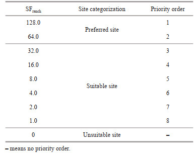
The suitability of marine ranching site selection is reflected by the suitability index of marine ranching sites. If the marine ranching suitability index value is 128.0, the area is of priority in the selection of marine ranching as all marine resource and environmental conditions meet the resource niche demand for marine ranching construction. Among the eight resource demand niches, seven marine resource and environmental conditions are superior. In this case, the marine ranching suitability index value is 64.0; the area is of priority as a marine ranching site. When a total six of marine resource and environmental conditions are superior, a marine ranching suitability index value of an area is 32.0. Similarly, if five, four, three, two conditions and even one condition are superior, the index values are 16.0, 8.0, 4.0, 2.0, and 1.0, respectively. In all these cases, the area can be considered suitable as a marine ranching site. The area is not suitable for marine ranching if the marine ranching suitability index value is 0. This is because not even one of the marine resource and environmental conditions has been met. The resource niche demand has become a nichelimiting factor for marine ranching construction, resulting in the region being unsuitable as a marine ranching site. Evaluation results of site suitability for marine ranching are summarized in Table 2.
GIS is a comprehensive analysis and processing technology, and is widely used in the research of spatial information management for natural resources such as agriculture, forestry, grassland, and oceans (Jarnevich et al., 2010). In view of the spatial differences in niche indicators of marine ranching site selection, we used a GIS spatial analysis model to study and construct a GIS-based niche suitability evaluation method for marine ranching site selection. First, the SHP files of the spatial evaluation unit were constructed using GIS technology for offshore areas of Guangdong Province. Second, we established an attribute table of niche suitability evaluation data for marine ranching selection by adding eight property fields—ST, SS, SQ, PP, DH, FR, WT, and SP. Then, attribute fields were superimposed and calculated to obtain the marine ranching site suitability index of each evaluation unit according to the established niche suitability evaluation model. Finally, the status and priority order of marine ranching site selection for each evaluation unit were determined according to the decision-making table (Table 2).
3 RESULT 3.1 Site conditions and resources suitability for marine ranchingRelationships between the conditions and resources and the niche demand for marine ranching in 40 selection sites in Guangdong Province were analyzed based on the eight niche resource requirements.
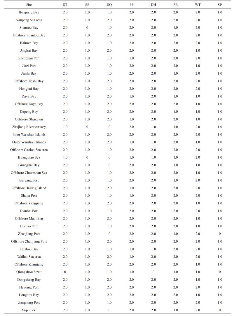
Regarding submarine topography suitability, the topography slope of the Qiongzhou Strait is greater than 5°. Thus, the submarine topography suitability of this site is assigned a value of 0, which is not suitable for marine ranching site selection. The topography slopes of the Huangmao Sea and Wanshan Islands range from 1° to 5° and the submarine topography suitability value is 1.0, indicating that these two sites are suitable as a location for marine ranching. The submarine topography slopes of the other 37 sites are less than 1°, and the submarine topography suitability value is 2.0; these are established sites for marine ranching.
In terms of seafloor sediment suitability, the seafloor sediments of Shantou Bay, Zhujiang (Pearl) River estuary, and Huangmao Sea are dominated by silt, with thick sediment deposits. Therefore, the seabed sediment suitability value of these sites is 0, which is not suitable for marine ranching sites. The seafloor sediment types of the other 37 sites are sandy and bedrock, and seafloor sediment suitability is assigned a value of 1.0. Therefore, these are suitable sites for marine ranching.
The seawater quality of the Zhujiang River estuary, Huangmao Sea, Guanghai Bay, Zhanjiang Port, and Anpu Bay is of Class Ⅲ or worse, and the seawater quality values of these sites are 0; hence, these areas are not suitable for marine ranching. The seawater of Houjiang Bay, Shantou Bay, Haimen Bay, Shenquan Port, Jiazi Port, Jieshi Bay, Honghai Bay, Gaolan Sea area, offshore Chuanshan, Beijin Port, Shaba Port, Dianbai Port, Bomao Port, Leizhou Bay, Qiongzhou Strait, and Jianghong Port is of class Ⅱ water quality. The seawater quality values of these sites are 1.0. Further, the seawater quality of the other 19 sites is of Class Ⅰ, and the seawater quality values are 2.0.
The marine primary productivity of 11 sites (including Shenquan Port, Daya Bay, Dapeng Bay, offshore Shenzhen, Outer Wanshan Islands, Huangmao Sea, offshore Hailing Islands, Shaba Port, Leizhou Bay, Wailuo Sea area, and Qiongzhou Strait) range from 100 to 200 g C/(m2·a); hence, the primary productivity value of these sites is 1.0. Marine primary productivity of the other 29 sites is > 200 g C/(m2·a), and the primary productivity value is 2.0.
Water depth across the 40 sites range between 5 and 50 m, implying that these sites meet the required water depth conditions. The current velocity in the Qiongzhou Strait is mostly > 1.50 m/s; hence, the marine hydrodynamic suitability value is 0. The current velocities in the Zhujiang River estuary, Outer Wanshan Islands, Huangmao Sea, and Leizhou Bay range from 1.0 to 1.5 m/s and the marine hydrodynamic suitability value is 1.0. The current velocities in the other 35 sites are < 1.0 m/s, and their marine hydrodynamic suitability value is 2.0.
Twenty-nine sites (including Houjiang Bay, Nanpeng Sea area, offshore Shantou Bay, Haimen Bay, Jinghai Bay, Shenquan Port, Jiazi Port, offshore Jieshi Bay, Honghai Bay, offshore Daya Bay, offshore Shenzhen, inner Wanshan Islands, outer Wanshan Islands, Gaolan Sea area, offshore Chuanshan, offshore Hailing Islands, Shaba Port, offshore Yangjiang, Dianbai Port, offshore Maoming, Bomao Port, offshore Zhanjiang Port, Leizhou Bay, Wailuo Sea area, offshore Zhanjiang, Dongchang Bay, Haikang Port, Longdou Bay, and Jianghong Port) are located in traditional marine fishery areas of Guangdong Province. Thus, these sites are most suitable for marine ranching (fishery resource suitability value of 2.0). The other 11 sites are located in the surrounding areas of the traditional marine fishery area, and their fishery resource suitability values are 1.0.
Twenty-four sites (including Houjiang Bay, Nanpeng Sea area, Shantou Bay, offshore Shantou Bay, Haimen Bay, Shenquan Port, Jieshi Bay, offshore Jieshi Bay, Honghai Bay, Zhujiang River estuary, inner Wanshan Islands, Gaolan Sea area, Huangmao Sea, Beijin Port, Hailing Island, Shaba Port, Dianbai Port, Zhanjiang Port, offshore Zhanjiang Port, Leizhou Bay, Wailuo Sea area, Haikang Port, Jianghong Port, and Anpu Port) are located in or nearby national central fishing ports and are convenient for land and sea transportation. Thus, the land-sea transportation suitability value of these sites is 2.0. The other 16 sites are located near general fishing ports or within 50 and 100 km from national central fishing ports, and land-sea transportation is relatively convenient. The land-sea transportation suitability value for these 16 sites is 1.0.
Both Zhanjiang Port and Qiongzhou Strait are considered functional areas for marine transportation, whereas Anpu Port is a functional area for industrial and urban construction. These three sites are incompatible for marine ranching and their marine spatial planning compliance value is 0. The other 37 sites meet the marine ranching site selection requirements of marine functional zoning and their marine space planning compliance value is 1.0.
A quantitative table of niche matching is summarized for the marine ranching sites in Guangdong Province (Table 3).
The ecological suitability of the 40 sites in offshore areas of Guangdong Province was evaluated using the ecological suitability evaluation model for marine ranching construction. The ecological suitability and priority order of the sites were determined according to the marine ranching suitability index.
The marine ranching suitability index of Guangdong Province is shown in Fig. 2. The highest value of the marine ranching suitability index is 128.0, which is distributed in the offshore Shantou Bay, offshore Zhanjiang Port, and Longdou Bay. The second highest marine ranching suitability index is 64.0, obtained for 17 selected sites (including Nanpeng Sea area, Jinghai Bay, Shenquan Port, Jiazi Port, offshore Jieshi Bay, Honghai Bay, offshore Daya Bay, offshore Shenzhen, inner Wanshan Islands, Gaolan Islands, offshore Hailing Island, offshore Yangjiang, offshore Maoming, offshore Zhanjiang, Wailuo Sea area, Dongchang Bay, and Haikang Port). The marine ranching suitability indices of 6 regions (Haimen Bay, Jieshi Bay, outer Wanshan Islands, Shapa Port, Dianbai Port, and Dapeng Bay) are 32.0. The sites with a marine ranching suitability index of 16.0 include Houjiang Bay, Daya Bay, offshore Chuanshan, Leizhou Bay, and Hongjiang Port. Beijin Port and Bomao Bay have a marine ranching suitability index of 8.0. The marine ranching suitability index is 0 for seven sites (Anpu Port, Qiongzhou Strait, Zhanjiang Port, Guanghai Bay, Huangmao Sea, Zhujiang River estuary, and Shantou Bay).

|
| Fig.2 Site suitability index for marine ranching in Guangdong Province |
The sites suitable for marine ranching in Guangdong Province are shown in Fig. 3. Among the 40 selected sites in the offshore areas of Guangdong Province, 20 sites (Nanpeng Sea area, offshore Shantou Bay, Haimen Bay, Jinghai Bay, Shenquan Port, Jiazi Port, offshore Jieshi Bay, Honghai Bay, offshore Daya Bay, offshore Shenzhen, Inner Wanshan Islands, Gaolan Sea area, offshore Hailing Islands, offshore Yangjiang, offshore Maoming, offshore Zhanjiang, offshore Zhanjiang Port, Haikang Port, Longdou Bay, and Dongchang Bay) are preferential sites for marine ranching. Thirteen sites (Houjiang Bay, Guanghai Bay, Jieshi Bay, Daya Bay, outer Wanshan Islands, offshore Chuanshan, Beijin Port, Shapa Port, Dianbai Port, Bomao Sea area, Leizhou Bay, and Hongjiang Bay) are suitable for marine ranching. Whereas, Shantou Bay, Zhujiang River estuary, Huangmao Sea, Guanghai Bay, Zhanjiang Port, Qiongzhou Strait, and Anpu Port are not suitable for marine ranching.

|
| Fig.3 Suitable sites for marine ranchingin Guangdong Province |
According to the calculation results of the suitability index for marine ranching site selection in Guangdong Province, the highest value of the suitability index is 128.0, followed by scores of 64.0, 32.0, 16.0, 8.0, and 0. This study proposed the principle that the higher the suitability index score of one region, the more priority this region is given as a marine ranching site. The top priority sites with a site suitability index of 128.0 are offshore Shantou Bay, offshore Zhanjiang Port, and Longdou Bay. The second priority sites with a site suitability index of 64.0 are distributed in 17 locations, which are Nanpeng Sea area, Jinghai Bay, Shenquan Port, Jiazi Port, offshore Jieshi Bay, Honghai Bay, offshore Daya Bay, offshore Shenzhen, Inner Wanshan Islands, Gaolan Islands, offshore Hailing Islands, Wailuo Sea area, offshore Zhanjiang, offshore Yangjiang, offshore Maoming, Dongchang Bay, and Haikang Port. The third priority sites with a site suitability index of 32.0 are Haimen Bay, Jieshi Bay, outer Wanshan Islands, Shapa Port, Dianbai Port, and Dapeng Bay. Five sites—Houjiang Bay, Daya Bay, offshore Chuanshan Sea, Leizhou Bay, and Hongjiang Port—are identified as fourth priority sites with a site suitability index of 16.0 for marine ranching. The fifth priority sites with a site suitability index of 8.0 are Bomao Port and Beijin Port. The remaining seven sites were not suitable for marine ranching, with a site suitability index of 0. The priority order of suitable marine ranching sites in the offshore areas of Guangdong Province is shown in Fig. 4.

|
| Fig.4 Priority order of suitable sites for marine ranching in Guangdong Province |
According to the marine functional zoning of Guangdong Province, the agricultural and fishery zones are suitable for construction of marine ranching with fish resource conservation and proliferation. The reserved zones of marine functional zoning are suitable for marine ranching with fishery resource conservation. In addition, tourism and entertainment zones of marine functional zoning are suitable for marine ranching with fishery tourism and conservation. Among the 33 suitable selected sites for marine ranching, twenty sites (Houjiang Bay, Nanpeng Islands, offshore Shantou Bay, Jinghai Bay, Shenquan Port, Jiazi Port, Jieshi Bay, offshore Daya Bay, offshore Chuanshan Sea, offshore Hailing Island, Beijin Port, Shapa Port, offshore Yangjiang, offshore Maoming, offshore Zhanjiang Port, offshore Zhanjiang, Wailuo Sea area, Haikang Port, Longdou Bay, and Hongjiang Bay) are located in agricultural and fishery zones and are suitable for both fish resource conservation and proliferation. Six sites (Daya Bay, offshore Jieshi Bay, inner Wanshan Islands, outer Wanshan Islands, Leizhou Bay, and Dongchang Bay) are located in the reserved zones of marine functional zoning and are suitable for fish resource conservation. Moreover, Dapeng Bay, offshore Shenzhen, Honghai Bay, Bomao Bay, Haimen Bay, Gaolan Sea area, and Dianbai Port, located in the tourism and entertainment zones are suitable for both fish resource conservation and recreation. The suitability of marine ranching types distributed offshore in Guangdong Province is shown in Fig. 5.

|
| Fig.5 Spatial distribution of types of marine ranching construction in Guangdong Province |
Several factors affect site selection for marine ranching. Heaps et al. (1997) reported that the factors that affect site selection for marine ranching include the physical marine environment, the biological environment, and socio-economic factors. Alwin (2021) selected a site for artificial reefs in Florida by considering sediment type, water depth, fishing piers, seaweed fields, biological refuges, restricted areas, and so on. In the present study, eight limiting factors—submarine topography, seafloor sediments, seawater quality, seawater depth and hydrodynamics, primary productivity, fishery resources, water and land transportation, and marine spatial planning—were selected based on the characteristics of the subtropical sea areas in the Guangdong Province. The factors proposed above are in accordance with the results of Heaps et al. (1997). Xu(2012, 2013) whom calculated the comprehensive evaluation index of suitability for marine ranching site selection primarily using the analytic hierarchy process. However, they did not consider the limiting effect of individual factors on marine ranching site selection; these factors can limit the locations of marine ranching regardless of the high values of suitability factors. O'Leary et al. (2001) proposed a constraint mapping condition method regarding artificial reef site selection, which reported that an area would not be suitable for marine ranching site selection even if one of the influencing factors did not meet the niche requirements of marine ranching (Song et al., 2022). In terms of the niche requirements for key functional groups, environmental suitability, transportation convenience, and spatial function management compliance of marine ranching construction, this study selected eight resource niche demands with the matching rules of niche suitability and established a site ecological suitability model of marine ranching by using the GIS spatial analysis method (Tseng et al., 2001).
This suitability evaluating method for marine ranching site selection not only reflects the veto effect of marine resource and environmental constraint, but also displays the positive effect of marine resources and superior environmental conditions on marine ranching. These make the suitability evaluation results of marine ranching site selection more reliable. In addition, the GIS-based model for calculating the suitability index of marine ranching site selection can realize the spatial differential expression of the evaluation index and evaluation results, thus forming a map-oriented management for marine ranching site selection. The GIS-based method requires a comprehensive survey to obtain spatial raster or vector data of marine resources and environment in the studied area. Moreover, a large amount of data is needed to investigate the status of marine resources and the environment. If spatial data of marine resources and the environment is incomplete or inaccurate, it is difficult to obtain objective and accurate suitability evaluation results for marine ranching site selection.
5 CONCLUSIONBased on the niche analysis of marine ranching site selection, in this study we proposed a site suitability map for marine ranching selection in offshore areas of Guangdong Province by establishing a niche suitability analysis method and an ecological suitability evaluation model. The Nanpeng Sea area, offshore Shantou, Honghai Bay, Jinghai Bay, Shenquan Port, Jiazi Port, offshore Jieshi Bay, Honghai Bay, offshore Daya Bay, offshore Shenzhen, inner Wanshan Islands, Gaolan Sea area, offshore Hailing Island, offshore Yangjiang, offshore Maoming, offshore Zhanjiang, offshore Zhanjiang Port, Haikang Port, Longdou Bay, and Dongchang Bay (20 sites) are preferential sites for marine ranching with a marine ranching suitability index of > 64.0. Houjiang Bay, Haimen Bay, Dapeng Bay, Jieshi Bay, Daya Bay, outer Wanshan Islands, offshore Chuanshan, Beijin Port, Shapa Port, Dianbai Port, Bomao Port, Leizhou Bay, and Hongjiang Bay (13 sites) are suitable sites for marine ranching with an ecological suitability index ranging from 8.0 to 32.0. Shantou Bay, Zhujiang River estuary, Huangmao Sea, Guanghai Bay, Zhanjiang Port, Qiongzhou Strait, and Anpu Port (seven sites) are unsuitable for marine ranching and have a marine ranching suitability index of 0. According to the marine ranching suitability index, marine functional zoning, and the urban spatial layout of Guangdong Province, six sites (e.g., Daya Bay, Jieshi Bay, inner Wanshan Islands) were identified as suitable for fish resource conservation. Seven sites (e.g., Dapeng Bay, offshore Shenzhen, and Honghai Bay) were suitable for fish resource conservation and recreation; 20 sites (Houjiang Bay, Nanpeng Islands, offshore Shantou Bay, Jinghai Bay, Shenquan Port, Jiazi Port, Jieshi Bay, offshore Daya Bay, offshore Chuanshan, offshore Hailing Islands, Beijin Port, Shapa Port, offshore Yangjiang, offshore Maoming, offshore Zhanjiang Port, offshore Zhanjiang, Wailuo Sea area, Haikang Port, Longdou Bay, and Hongjiang Bay) were suitable for fish resource conservation and proliferation.
6 DATA AVAILABILITY STATEMENTThe datasets generated during and/or analyzed during the current study are available from the corresponding author on reasonable request.
Alwin H, Quirine C A H, Callum B R, et al. 2021. Artificial reefs in the Caribbean: A need for comprehensive monitoring and integration into marine management plans. Ocean & Coastal Management, 209(1): 1-10.
|
Ash TM. 2006. Artificial Reef Management Plan Tampa Bay/Hillsborough County, Florida. Environmental Protection Commission of Hillsborough County.
|
Brotons L, Thuiller W, Araújo M B, et al. 2004. Presenceabsence versus presence-only modelling methods for predicting bird habitat suitability. Ecography, 27(4): 437-448.
DOI:10.1111/j.0906-7590.2004.03764.x |
Chen X J, Tian S Q, Liu B L, et al. 2011. Modeling a habitat suitability index for the eastern fall cohort of Ommastrephes bartramii in the central North Pacific Ocean. Chinese Journal of Oceanology and Limnology, 29(3): 493-504.
DOI:10.1007/s00343-011-0058-y |
China Gulf History Compilation Committee. 1998. China Gulf History: The Ninth Volume. Ocean Press, Beijing, China.
(in Chinese)
|
China Gulf History Compilation Committee. 1999. China Gulf History: Book Ten. Ocean Press, Beijing, China.
(in Chinese)
|
Ding C C, Hu Y M, Li C W, et al. 2018. Distribution and habitat suitability assessment of the gaur Bosgaurus in China. Biodiversity Science, 26(9): 951-961.
(in Chinese with English abstract) DOI:10.17520/biods.2018012 |
Elton C E. 1927. Animal Ecology. Sidgwick & Jackson, London. 204p.
|
Seyed H M, Afshin D, Mohammad R S, et al. 2015. Site selection for artificial reefs using a new combine MultiCriteria Decision-Making (MCDM) tools for coral reefs in the Kish Island—Persian Gulf. Ocean & Coastal Management, 111: 92-102.
|
Erftemeijer P, DeGraaff R, Boot G. 2004. Site selection for artificial reefs in Bahrain (Arabian Gulf) based on GIS technology and hydrodynamic modelling. Journal of Marine Science and Environment, C2: 29-38.
|
Guangdong Local History Compilation Committee. 2004. Guangdong Provincial History: Aquatic Product Volume. Guangdong People's Publishing House, Guangzhou, China. (in Chinese)
|
Heaps L M, Picken G B, Ray S. 1997. Site selection and environmental criteria-a case study. In: Jensen A C ed. European Arti fi cial Reef Research. Proceedings of the First EARRN Conference. Ancona, Italy. p. 405-421.
|
Hwang B K, Lee Y W, Jo H S, et al. 2015. Visual census and hydro-acoustic survey of demersal fish aggregations in Uljusmall scale marine ranching area (MRA), Korea. Journal of the Korean Society of Fisheries and Ocean Technology, 51(1): 16-25.
DOI:10.3796/KSFT.2015.51.1.016 |
Jarnevich C S, Holcombe T R, Barnett D T, et al. 2010. Forecasting weed distributions using climate data: a GIS early warning tool. Invasive Plant Science and Management, 3(4): 365-375.
DOI:10.1614/IPSM-08-073.1 |
Jia X P, Li C H, Qiu Y S. 2005. Investigation and Evaluation of Marine Fishery Resources and Sustainable Utilization Countermeasures in Guangdong Province. Ocean Press, Beijing.
(in Chinese)
|
Kim S K, Yoon S C, Youn S H, et al. 2014. Morphometric changes in the cultured starry flounder, Platichthys stellatus, in open marine ranching areas. Journal of Environmental Biology, 34(2): 197-204.
|
Kocev D, Naumoski A, Mitreski K, et al. 2010. Learning habitat models for the diatom community in Lake Prespa. Ecological Modelling, 221(2): 330-337.
DOI:10.1016/j.ecolmodel.2009.09.002 |
Lan C H, Chen C C, Hsui C Y. 2004. An approach to design spatial configuration of artificial reef ecosystem. Ecological Engineering, 22(4-5): 217-226.
DOI:10.1016/j.ecoleng.2004.04.004 |
Odum E P. 1971. Fundamentals of Ecology. 3rdedn. W. B. Saunders Co., Philadelphia. 574p.
|
Song M P, Wang J H, Nie Z Y, et al. 2022. Evaluation of artificial reef habitats as reconstruction or enhancement tools of benthic fish communities in northern Yellow Sea. Marine Pollution Bulletin, 182(7): 1-10.
|
O'Leary E, Hubbard T, O'Leary D. 2001. Artificial reefs feasibility study. Marine Institute, 30: 3-28, http://hdl.handle.net/10793/215.
|
Ouyang Z Y, Wang R S, Fu G N. 1996. Ecological niche suitability model and its application in land suitability assessment. Acta Ecologica Sinica, 16(2): 113-120.
(in Chinese with English abstract) |
Stalnaker C B, Lamb B L, Henriksen J et al. 1995. The instream flow incremental methodology: a primer for IFIM. National Biological Service, US Department of the Interior, Fort Collins, Colorado. p. 17-19.
|
Sun Z Y. 1983. Discussion on choosing a suitable site for new harbour in Qingdao port. Coastal Engineering, 2(2): 59-68.
(in Chinese with English abstract) |
Tseng C T, Chen S C, Huang C S, et al. 2001. GIS-assisted site selection for artificial reefs. Fisheries Science, 67(6): 1015-1022.
DOI:10.1046/j.1444-2906.2001.00356.x |
Wright R, Ray S, Green D R, et al. 1998. Development of a GIS of the Moray Firth (Scotland, UK) and its application in environmental management (site selection for an 'artificial reef'). Science of the Total Environment, 223(1): 65-76.
DOI:10.1016/S0048-9697(98)00310-6 |
Xu Q. 2012. Study of Site Selection of Marine Ranching—Take Zhoushan Islands as an Example. MD, Shanghai Ocean University, Shanghai. (in Chinese with English abstract)
|
Xu Q, Zhang S Y. 2013. Site selection evaluation of marine ranching in Zhoushan area based on AHP method. Journal of Shanghai Ocean University, 22(1): 128-133.
(in Chinese with English abstract) |
Xu Y, Bao C G, Liang B, et al. 2016. Suitability evaluation of artificial reefs site selection in Tianjin offshore waters area. Marine Environmental Science, 35(6): 846-852.
(in Chinese with English abstract) |
Yang H S. 2016. Construction of marine ranching in China: reviews and prospects. Journal of Fisheries of China, 40(7): 1133-1140.
(in Chinese with English abstract) |
Zhang G S, Chen Y, Zhang P D, et al. 2003. Significance and feasibility of establishing marine ranching in Chinese sea area. Journal of Dalian Fisheries University, 18(2): 141-144.
(in Chinese with English abstract) |
Zhao H T. 1999. Geomorphology and Environment of the South China Coast and the South China Sea Islands. Science Press, Beijing, China.
(in Chinese)
|
Zhou W G, Ding D W, Suo A N, et al. 2021. Key functional groups selection in marine ranching fishery resources from the Pearl River Estuary. Journal of Fisheries of China, 45(3): 433-443.
(in Chinese with English abstract) DOI:10.11964/jfc.20191212111 |