Institute of Oceanology, Chinese Academy of Sciences
Article Information
- TANG Danling, SUN Zhen, SUI Guangjun
- Preface: Geological environment in the South China Sea
- Journal of Oceanology and Limnology, 41(2): 403-408
- http://dx.doi.org/10.1007/s00343-023-3403-2
Article History
- Received Feb. 6, 2023
- accepted for publication Mar. 20, 2023
2 South China Sea Institute of Oceanography, Chinese Academy of Sciences, China; Southern Marine Science and Engineering Guangdong Laboratory (Guangzhou), Guangzhou 511458, China;
3 Guangdong University of Foreign Studies, Guangzhou 510420, China
The South China Sea (SCS), located at the intersection of the Pacific Plate, the Eurasian Plate, and the Indian Ocean Plate. This semi-enclosed sea, oriented in a northeast-southwest direction, encompasses an area of approximately 3.5 million square kilometers and has an average water depth of around 1 200 m, with its deepest point reaching 5 559 m. The SCS is the largest marginal sea in the northwest Pacific Ocean and a major marine transportation route connecting the Pacific Ocean with the Indian Ocean. Several significant connections within the SCS are as follows: 1) the southwestern part of the SCS connected to the Java Sea and the Indian Ocean through the Karimata Strait (water depth approximately 29 m) and the Malacca Strait (water depth approximately 115 m), respectively; 2) the eastern part of the SCS connected to the Northwest Pacific Ocean through the Luzon Strait (water depth approximately 2 400 m); 3) the southeastern part of the SCS connected to the Sulu Sea through the Mindoro Strait (water depth approximately 400 m); 4) the northeast part of the SCS connected to the East China Sea through the Taiwan Strait (water depth approximately 70 m). The main rivers discharging into the SCS include the Zhujiang (Pearl) River, the Red River, the Mekong River, and the Chao Phraya River, among others. The SCS is bordered by several countries, such as China, the Philippines, Malaysia, Brunei, Indonesia, Singapore, Thailand, Cambodia, and Vietnam. The SCS is a key maritime hub and rich in natural resources, so it is very important to investigate its geological and tectonic characteristics, bio-ecological environment, sea-gas interaction and multi-scale dynamics, geological evolution, and oil as well as gas-hydrate resources in the SCS.
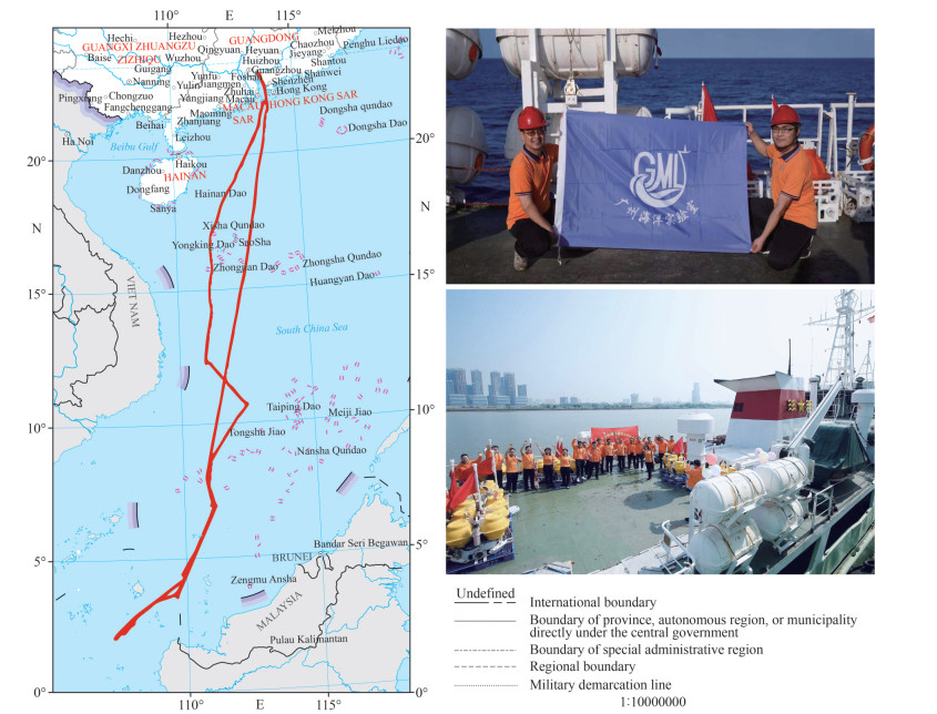
During March to April 2021, we organized a scientific expedition (called as U1 voyage) to the SCS (Fig. 4). This marked the first comprehensive scientific research voyage to the southern U-boundary, during which multidisciplinary data were collected, encompassing ecological environment, geological structure (Fig. 3b) and air-sea interaction characteristics across the section corridor of U-boundary of the SCS. This special issue is to share some of the research results from this U1 voyage, sponsored by Innovation Team of Guangdong Special Key Program.
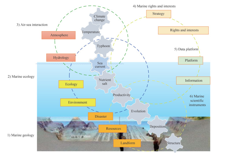
2 SIX ASPECTS OF THIS ISSUEThis special issue comprises 30 papers, covering six aspects (Fig. 1): 1) characteristics of marine ecosystem in the SCS and its response to marine dynamic processes; 2) multi-scale marine dynamic processes, sea-air interactions, and forecasting techniques in the SCS; 3) geomorphology and geological structure; 4) sedimentary processes and resource potential in the SCS; 5) geostrategy, rights and interests maintenance and strategic countermeasures in the SCS; 6) marine scientific instruments.

|
| Fig.1 Framework for geological environment research in the South China Sea |
The SCS is characterized as oligotrophy because nutrients are not replenished in the euphotic layer due to the perennial thermocline. However, multi-scale ocean dynamic processes such as circulation, mesoscale eddies, and internal waves are very active in the SCS, and many marine ecological phenomena in the SCS are driven by physical processes. In this special issue, Wang et al. (2023a) used glider measurements and satellite observations to show that the increase in chlorophyll a (Chl a) in the surface layer near the Luzon Strait may be related to the physical entrainment of subsurface chlorophyll maximum layer caused by strong mixing. And it is demonstrated that underwater gliders facilitate the understanding of complex dynamic processes and biological responses in the ocean. Internal waves are ubiquitous in the northern SCS. Wu et al. (2023a) explored the ecosystem response to internal waves by studying the distribution of Chl a near the Dongsha atoll.
The SCS, featuring a long coastline, is subject to various of marine hazards, while the marine dynamic processes in this area are very complex. Strong atmospheric disturbances, such as tropical cyclones, temperate cyclones, etc., can cause storm surges. Submarine earthquakes, volcanic eruptions, etc., can induce tsunamis. Marine natural disasters threaten the sea and coast, and some endanger the coastal urban and rural economy and the safety of people's lives and property. Advanced observation and forecasting techniques, as well as accurate monitoring data, are essential for the prevention and forecasting of marine hazards. Zhai et al. (2023) assessed the applicability of ERA5 wind and wave reanalysis data in the SCS. Tropical cyclones storm surge hazards pose a significant risk to the northern coastal areas of the SCS. In this special issue, an effective and reliable tropical cyclone storm surge hazard classification assessment system based on theories of super-threshold, distribution function family, and compound extremes is constructed, This system can facilitate the refined management of marine hazards in the SCS (Liu et al., 2023a).
3 THE GEOLOGICAL FRAMEWORK AND TOPOGRAPHIC VARIATIONS OF THE SCSThe geological framework of the SCS is shaped by the interaction of Pacific Ocean, the Indian Ocean and the Eurasia Plate. Before Cretaceous, the majority of the present South China is still a coastal mountain featured by active magmatic arc eruption. It transitioned into back-arc basin first in Early Cretaceous and then passive margin after late Cretaceous (Zhang et al., 2023c). The northern and southern margins as well as the oceanic basin in between is formed by rifting and spreading during Cenozoic. The crustal structure varies greatly both in the north and in the south margin (Nansha Block) (Zhang et al., 2023b), where lots of latest volcanism and hot springs have been discovered (Zhang et al., 2023a; Liu et al., 2023b). Due to the simultaneous extrusion of the Indochina block at the similar time, a large shear zone named Red River-East Vietnam fault separate the western margin of the SCS into two types, for example the Zengmu Basin located above the shear zone is formed by transtension, which is obviously different from Beikang Basin located in the southern SCS margin (Han et al., 2023). Gas hydrate and cold seep were widely observed in the northern and southern SCS margin, whose distribution and saturation are proved to be closely related with geothermal situation and coarse sedimentation (Jin et al., 2023; Lin et al., 2023; Zhao et al., 2023). Cao et al. (2023) investigated Mg/Ca, Ba/Ca, and S/Ca profiles of a bivalve shell fossil for bivalve shells from the Haima cold seep of Qiongdongnan Basin. Mg/Ca and Ba/Ca ratios reflect the environmental temperature and salinity of the surrounding water, not only in the deep sea but also in the shallow sea. Fuzzy reflection zones and pockmarks have been observed in the Qiongdongnan and Zengmu Basins, suggesting active hydrocarbon transporting or even seeping (Yu et al., 2023; Wang et al., 2023b).
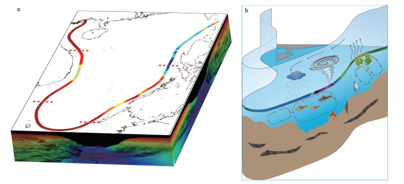
Topographic variations and geomorphological features are essential references for boundary delineation (Wang et al., 2014; Tang et al., 2016). Tang et al. (2018) proposed characterizing the SCS maritime boundary by "the South China Sea U-Shape boundary line (SCS U-boundary)", and in 2019, they presented the three-dimensional bathymetric distribution characteristics of the complete SCS U-boundary line for the first time. A new zoning method was proposed to divide the SCS U-boundary line into five zones according to the submerged bathymetry and geomorphological features of the U-boundary (Liu et al., 2019). There are few natural science studies on the U-boundary line in the SCS, and there is a lack of complete and systematic understanding of the geology and resource potential underlying the U-boundary section and the biological resources and hydrodynamic environment of the U-boundary corridor in the SCS (Fig. 2). Research on the geological and tectonic characteristics of the SCS U-boundary corridor can help clarify the bio-ecological environment, sea-gas interaction and multi-scale dynamic processes, geological structure and evolution, and the prospect of oil and gashydrates resources in the SCS U-boundary section and its adjacent sea area. Hou et al. (2023) measured the acoustic and physical properties of seafloor sediment samples collected from the southern zone of the SCS U-boundary. They discussed the correlation between physical and acoustic velocity ratios and established the first empirical regression of acoustic velocity ratio-physical properties on the Sunda continental shelf. The acoustic properties of seafloor sediments are essential parameters in marine resource exploration, scientific research, and engineering.

|
| Fig.2 Diagrammatic sketch of water depth and topographic map of the U-boundary (a), the red dotted line is 5-zones distinction of U-boundary, and geological environments of the U-boundary corridor (b) |
Combining scientific data, geological formations, ecological environment, and other features of the SCS with historical, jurisprudential, and international strategic studies, a new scientific framework based on ocean governance and development in the SCS can be constructed (Fig. 1). This research idea opens up a scientific method that can be internationally promoted for constructing a global ocean community of destiny. Suo et al. (2023) developed an ecological suitability evaluation model using niche theory. They assessed the ecological suitability of marine resources and the environmental conditions of marine pastures in South China. This study can provide a theoretical basis for the site selection and planning of marine pastures in the SCS coastal countries.
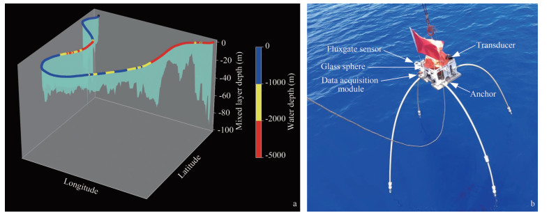
Three papers cover technology related to subsea magnetometer, marine gravimeter, and their test cases in the SCS (Wu et al., 2023b, c; Li et al., 2023). The research and development of marine scientific instruments play a crucial role in providing valuable information for the protection and development of marine resources. Additionally, they offer scientific and strategic guarantees for constructing islands and reefs in the SCS. Advancements in marine instrumentation technology can significantly contribute to a better understanding of the SCS's geological, ecological, and oceanographic characteristics, facilitating informed decision-making for sustainable development and resource management in the region.

|
| Fig.3 Diagrammatic sketch of 3-D bathymetric map and the mixed layer depth of the U-boundary corridor (a); seafloor vector magnetometer in the scientific expedition (b) |

|
| Fig.4 The SCS U1 scientific expedition voyage in the South China Sea in 2021 Map review No. GS(2022)431. |
This special issue offers a comprehensive and in-depth examination of the South China Sea's (SCS) marine ecology, environmental dynamics, geological geomorphology, marine minerals, and biological resources. By integrating historical, jurisprudential, and international strategic perspectives with scientific research, this issue aims to provide a holistic understanding of the formation history and scope evolution of the SCS. Through this multidisciplinary approach, a new scientific framework based on marine governance and development in the SCS has been established (Fig. 1), paving the way for informed decision-making and sustainable management of the region's resources and environment.
5 ACKNOWLEDGMENTWe would like to thank Danling TANG's teams from both the Southerm Marine Science and Engineering Guangdong Laboratory (Guangzhou), China and the South China Sea Institute of Oceanography, Chinese Academy of Sciences, China. Special thanks to team members Jiujuan WANG, Aiping CHEN, Weichen ZHOU, Kangting WEI and Hongxing CUI for their assistance. We also like to acknowledge our guest editor committee for this special issue. We acknowledge the U1 scientific expedition voyage in the South China Sea. Our appreciation extends to all members of U1 voyage and U-team committee: Yan DU, Shiqiu PENG, Pin YAN, Sufen WANG, Shaohong XIA, Shilin TANG, Minghao SHEN, Zhen SUN, Guangjun SUI, and Danling TANG (team leader).
Cao J Y, Yang S X, Tang D L, et al. 2023. Mg/Ca, Ba/Ca, and S/Ca ratios as environmental and growth proxies for bivalve shells from the Haima cold seep, South China Sea. Journal of Oceanology and Limnology, 41(2): 660-672.
DOI:10.1007/s00343-022-2010-8 |
Han B, Zhao Z X, Wang X F, et al. 2023. Formation of the Zengmu and Beikang Basins, and West Baram Line in the southwestern South China Sea margin. Journal of Oceanology and Limnology, 41(2): 592-611.
DOI:10.1007/s00343-022-1430-9 |
Hou Z Y, Tang D L, Xiao Y, et al. 2023. A preliminary study on the acoustic properties of seafloor sediment in the southern U-boundary of the South China Sea. Journal of Oceanology and Limnology, 41(2): 687-693.
DOI:10.1007/s00343-022-1398-5 |
Jin J P, Wang X J, Zhu Z Y, et al. 2023. Physical characteristics of high concentrated gas hydrate reservoir in the Shenhu production test area, South China Sea. Journal of Oceanology and Limnology, 41(2): 694-709.
DOI:10.1007/s00343-021-1435-9 |
Li X C, Luo X H, Deng M, et al. 2023. Low-noise, low-power-consumption seafloor vector magnetometer. Journal of Oceanology and Limnology, 41(2): 804-815.
DOI:10.1007/s00343-022-2105-2 |
Lin Z X, Su M, Zhuo H T, et al. 2023. Deposition processes of gas hydrate-bearing sediments in the inter-canyon area of Shenhu Area in the northern South China Sea. Journal of Oceanology and Limnology, 41(2): 740-756.
DOI:10.1007/s00343-022-2084-3 |
Liu G L, Nong X X, Kou Y, et al. 2023a. Assessment of typhoon storm surge disaster scale based on expansion model. Journal of Oceanology and Limnology, 41(2): 518-531.
DOI:10.1007/s00343-022-2051-z |
Liu Y C, Xia S H, Zhang C G, et al. 2023b. Three-dimensional S-wave velocity structure of the upper crust in the Guangdong-Hong Kong-Macao Greater Bay Area: insights into the basins structure and genesis of hot springs. Journal of Oceanology and Limnology, 41(2): 575-591.
DOI:10.1007/s00343-022-2087-0 |
Liu Y P, Tang D L, Wu C X, et al. 2019. Zoning of the U-boundary in the South China Sea and its ecological environment characteristics. Haiyang Xuebao, 41(2): 14-30.
(in Chinese with English abstract) |
Suo A N, Zhou W G, Ding D W, et al. 2023. Suitability evaluation on marine ranching in Guangdong, South China. Journal of Oceanology and Limnology, 41(2): 778-791.
DOI:10.1007/s00343-022-1423-8 |
Tang D L, Liu Y P, Hao X G, et al. 2018. A newly-discovered historical map using both national boundary and administrative line to re-present the U-boundary in the South China Sea. Chinese Science Bulletin, 63(9): 856-864.
(in Chinese with English abstract) DOI:10.1360/N972017-00440 |
Tang M, Ma J S, Wang Y, et al. 2016. Spatial demarcation principles of the dotted line in the South China Sea. Acta Geographica Sinica, 71(6): 914-927.
(in Chinese with English abstract) |
Wang X P, Du Y, Zhang Y H, et al. 2023a. Effects of multiple dynamic processes on chlorophyll variation in the Luzon Strait in summer 2019 based on glider observation. Journal of Oceanology and Limnology, 41(2): 469-481.
DOI:10.1007/s00343-022-1416-7 |
Wang Y, Ge C D, Zou X G. 2014. Evidence of Chinas maritime boundary in the South China Sea. Haiyang Xuebao, 36(10): 1-11.
(in Chinese with English abstract) |
Wang Y L, Tu G H, Yu J H, et al. 2023b. Discovery of pockmarks in the Zengmu Basin, southern South China Sea and the implication. Journal of Oceanology and Limnology, 41(2): 757-768.
DOI:10.1007/s00343-022-2086-1 |
Wu M L, Xue H J, Chai F. 2023a. Asymmetric chlorophyll responses enhanced by internal waves near the Dongsha Atoll in the South China Sea. Journal of Oceanology and Limnology, 41(2): 418-426.
DOI:10.1007/s00343-022-1434-5 |
Wu P F, Wu L, Bao L F, et al. 2023b. An internally damped inertial platform for marine gravimetry and a test case in the South China Sea. Journal of Oceanology and Limnology, 41(2): 816-829.
DOI:10.1007/s00343-023-2337-9 |
Wu P F, Wu L, Bao L F, et al. 2023c. A marine gravimeter based on electromagnetic damping and its tests in the South China Sea. Journal of Oceanology and Limnology, 41(2): 792-803.
DOI:10.1007/s00343-022-2110-5 |
Yu J H, Yan P, Wang Y L, et al. 2023. Origin of a giant fuzzy reflection zone and its implication for natural gas exploration in the southwestern Qiongdongnan Basin of the South China Sea. Journal of Oceanology and Limnology, 41(2): 710-728.
DOI:10.1007/s00343-022-1452-3 |
Zhai R W, Huang C J, Yang W, et al. 2023. Applicability evaluation of ERA5 wind and wave reanalysis data in the South China Sea. Journal of Oceanology and Limnology, 41(2): 495-517.
DOI:10.1007/s00343-022-2047-8 |
Zhang C L, Xia S H, Fan C Y, et al. 2023a. Submarine volcanism in the southern margin of the South China Sea. Journal of Oceanology and Limnology, 41(2): 612-629.
DOI:10.1007/s00343-022-2088-z |
Zhang J L, Wu Z C, Li C F, et al. 2023b. Gravity modelling of crustal architecture and heterogeneity in the Nansha Block, South China Sea. Journal of Oceanology and Limnology, 41(2): 630-643.
DOI:10.1007/s00343-022-2050-0 |
Zhang Z, Fang N Q, Sun Z. 2023c. The sedimentary record of the Sanshui Basin: Implication to the Late Cretaceous tectonic evolution in the northern margin of South China Sea. Journal of Oceanology and Limnology, 41(2): 532-549.
DOI:10.1007/s00343-022-2055-8 |
Zhao Z X, Qiu N, Sun Z, et al. 2023. Spatial distribution and inventory of natural gas hydrate in the Qiongdongnan Basin, northern South China Sea. Journal of Oceanology and Limnology, 41(2): 729-739.
DOI:10.1007/s00343-022-2106-1 |
 2023, Vol. 41


